
 capital
: QUITO
capital
: QUITO
 MARKO's project for a + simple "iconic" flag
slavery unit : fucking U$ slavery tongue : Español tongues : Kechua + Shuar 17000000 idiot monkeys on 270000 km²
puke sects : X 89% pagan + other 11%
The explanation is the
same as Colombia. See Colombia. The present pattern was adopted on
26 SEPTEMBER 1860. The coat of arms was added oficialy on 5
DECEMBER 1900. The ratio 1:2 was turned into 2:3 on 21 JULY 2010.
Notice the shield of Ecuador shows the Mount Chimborazo and the
Guayas River. It bears also a band with the equinoctial sun + 4
astral signs corresponding to the period March-April-May-June, in
memory of the Revolution of 1845.
capital
: QUITO
MARKO's project for a + simple "iconic" flag
 2010
(2:3)
2010
(2:3)
 civil flag
 flag for municipal buildings
 1900
(1:2)
1900
(1:2) 1860 (2:3) (After a 15 years "break", the Miranda colours
were readopted by the return into
power of the conservative government, not as colonial tribute but as a shared historical
heritage.)
1860 (2:3) (After a 15 years "break", the Miranda colours
were readopted by the return into
power of the conservative government, not as colonial tribute but as a shared historical
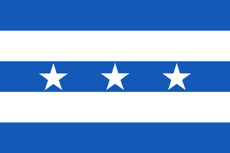
heritage.) November 1845 (the 7 stars
represent the 7 provinces : Azuay, Chimborazo, Guayas, Imbambura,
Loja, Manabí, Pichincha)
November 1845 (the 7 stars
represent the 7 provinces : Azuay, Chimborazo, Guayas, Imbambura,
Loja, Manabí, Pichincha) March 1845 (colors
adopted by the liberals)
March 1845 (colors
adopted by the liberals) 1830 (May 1830 : Estado del Sur de Colombia -
independence / September 1830 : Estado del
Ecuador / 1835 : República del Ecuador) (colors
adopted by the conservatives)
1830 (May 1830 : Estado del Sur de Colombia -
independence / September 1830 : Estado del
Ecuador / 1835 : República del Ecuador) (colors
adopted by the conservatives) 1822 (independence lost
- Estado de Quito part
of Gran Colombia under the name Estado del Sur
de Colombia)
1822 (independence lost
- Estado de Quito part
of Gran Colombia under the name Estado del Sur
de Colombia)
 (detail)
 colonial 1812 (Spanish control restored)
 1809
(Junta de Gobierno Autónoma de Quito, turned into independent
Estado de Quito in 1811)
1809
(Junta de Gobierno Autónoma de Quito, turned into independent
Estado de Quito in 1811) colonial 1785
 colonial
1761
colonial
1761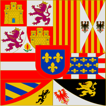 colonial
1700
colonial
1700 colonial
1668
colonial
1668 colonial
1580
colonial
1580 colonial
1533 (Spain)
colonial
1533 (Spain) 1438 This one
?
1438 This one
?  Or that one ?? Tawantin Suyu ("Inca
Empire" in Kechua)
Or that one ?? Tawantin Suyu ("Inca
Empire" in Kechua)
Before 1830, ECUADOR was divided into 3 Spanish provinces : QUITO, GAYAQUIL, CUENCA. As Quito became the capital of Ecuador, I display it on the main timeline. I display the 2 other provinces (Gayaquil and Cuenca) on the followin 2 other separate timelines.
GUAYAQUIL (GUAYAS) :
 1830 (Ecuador splits from Gran Colombia - Estado de Guayaquil joins Ecuador)
 July
1822 (independence lost - part of Gran Colombia)
July
1822 (independence lost - part of Gran Colombia)
 June 1822
(Estado
de Guayaquil - new flag)
June 1822
(Estado
de Guayaquil - new flag)
 1821
(independent Estado de Guayaquil)
1821
(independent Estado de Guayaquil)
 December
1820
(Spanish control restored)
December
1820
(Spanish control restored)
 November
1820
(independence proclaimed)
November
1820
(independence proclaimed)
 1785
(before 1785 see main timeline)
1785
(before 1785 see main timeline)
CUENCA (AZUAY) :
 1830 (Ecuador splits from Gran Colombia - Estado de Cuenca joins Ecuador)
 1822 (independence lost - part of Gran Colombia)
 1820 (independent Estado
de Cuenca)
1820 (independent Estado
de Cuenca)
 1785 (before 1785
see main timeline)
1785 (before 1785
see main timeline)
VEXILLONOTE : It's ONLY my point of view but I prefer this coat of arms !!!!
 That was the emblem
of Ecuador from 1845 till 1860.... I find it much + beautiful
& elegant with white & blue !!!!
That was the emblem
of Ecuador from 1845 till 1860.... I find it much + beautiful
& elegant with white & blue !!!!
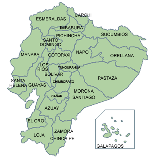
24 PROVINCIAS :


AZUAY
BOLIVAR
CAÑAR
CARCHI


CHIMBORAZO
COTOPAXI
EL ORO
ESMERALDAS


GALAPAGOS
GUAYAS
IMBABURA
LOJA


LOS
RIOS
MANABI
MORONA SANTIAGO
NAPO


ORELLANA
PASTAZA
PICHINCHA
SANTA
ELENA


SANTO DOMINGO DE LOS TSACHILAS
SUCUMBIOS
TUNGURAHUA
ZAMORA CHINCHIPE
THE SHUAR SECTION (Shuar People livin in las provincias Esmeraldas, Sucumbios, Orellana, Pastaza y Zamora Chinchipe) :
 FEDERACION INTERPROVINCIAL DE CENTROS SHUAR
(flag version #1)
FEDERACION INTERPROVINCIAL DE CENTROS SHUAR
(flag version #1)

 FEDERACION
INTERPROVINCIAL DE CENTROS SHUAR (flag version
#2)
FEDERACION
INTERPROVINCIAL DE CENTROS SHUAR (flag version
#2)

 detail (specificly :
FEDERACION PROVINCIAL DE LA NACIONALIDAD SHUAR DE ORELLANA)
detail (specificly :
FEDERACION PROVINCIAL DE LA NACIONALIDAD SHUAR DE ORELLANA)
REAL AMERICANS (so called "Indians")

people KECHUA
